View of Brisbane towards Story Bridge from City Hall Clock Tower, 8 January 1954. Story Bridge looms over the city in the background. The rising brown steel skeleton is the MLC office tower under construction, heralding the coming of the skyscrapers, effectively ending the interwar form of the city. Many interwar buildings are visible here.
Source: BCC Library Image number:
BCC-S35-9311022.
Story Bridge was the tallest built structure in Brisbane (and Queensland?) from its completion in 1940 until 1970. Construction started in 1935 as a means of providing work for unemployed men during the Great Depression. Its designer, JA Holt, modelled the bridge on the Montreal Harbour Bridge (a MUCH bigger span). The peaked elevation of the bridge was said to harmonise with Brisbane's natural skyline. From mid-1935 to 1940 the bridge was known as the Jubilee Bridge, honouring George V, but when opened on 6 July 1940 it was named after JD Story, the Public Service Commissioner and a member of the Bridge Board. Although an engineering success, the bridge was regarded initially as a white elephant, the toll being unpopular and the traffic demand negligible. Not until the arrival of American troops in 1942 was the Story Bridge fully utilised. Nevertheless, the final cost of £1.6 million was recuperated within seven years, and in 1947 the bridge was transferred to the Brisbane City Council and the toll was removed.
The Story Bridge has become one of Brisbane's most widely recognised landmarks. Its illumination, carried out by SEQEB in time for the 1986 Warana festival, reflects its unique status as a symbol of the city.
(Source: http://chims/chims/criteriaHistoryDetail.html?siteId=15015)
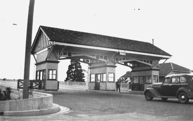
View of a car approaching the toll-gate at the Kangaroo Point end of the
Story Bridge. When the Story Bridge first opened
in 1940 the toll charge for motor cars carrying not more
than seven passengers was 6d. Other charges ranged from 1d for bicycles
to 1/6 for heavy vehicles (Information taken from: Strand
Press, The Story Bridge : a commemorative book, 1940).
Source: SLQ JOL Image number: 115336.
Looking down from the top of the northern ancilliary arm of the Story Bridge, Brisbane ca. 1938. A lot of these building were demolished to create Kemp Place, the offroads for the bridge.
Source: SLQ JOL Image number: APE-075-0001-0013.
The Story Bridge transformed the circulation of the city. The areas it connected were previously pockets, unused to major through traffic. The narrow peninsula of Kangaroo Point became overwhelmed by the wide highway approach. It was no longer a quiet residential area and it struggled for years (and in my opinion never recovered). The Fortitude Valley side of the bridge was better able to handle the circulation change and increased traffic but Kemp Place was a poorly done insertion into the fabric (and later worsened with the horrible Ivory Street underpass and the other mess at that end). However, the city was no longer the only place to cross the river in your car. This must have been a major shift in citizen's perceptions of the city spaces.
The bridge under construction, 1939, showing the highway bisecting the Kangaroo Point Peninsula.
Source: SLQ JOL Negative number: 60915.
It is a beautiful bridge. Actually, quite overscaled. It peaks out of the surrounding fabric in surprising ways.
JCC Bradfield's drawing, c1933 showing the bridge and the city skyline behind. At right, Bradfield has included Holy Name Cathedral, a victim of the Great Depression that was never built.
Source: NLA image number: nla.pic-an5812829 .
Story Bridge at Dusk, 9 September 1987.
Source: BCC Library, Image number:
BCC-T120-708
.


No comments:
Post a Comment